One of the greatest gifts geocaching can offer is the ability to find adventure anytime, anywhere. Whether you’re looking for a quick “park & grab” or a 100-mile (160km) journey across frozen tundra, there’s a cache out there waiting for you. For those interested in the extreme, break the ice with our next Geocache of the Week, Arctic Circle Trail (K –> S).

As hinted by the name, geocachers seeking to log GC3QR3J need to gear up (both mentally and physically) for a grueling hike, sure to exhaust your endurance, across the famed Arctic Circle Trail. The trail itself runs east-west along a massive fjord, connecting the coastal towns of Kangerlussuaq and Sisimiut.
GC3QR3J was designed for trekkers heading from east to west; however, the cache owner TriNitro has also placed a companion Multi-Cache intended for cachers going the opposite direction (GC3QR3K). Both caches weigh in at five stars in difficulty and terrain, so the mental and physical demands of this challenge should not be underestimated.

In the cache description, TriNitro notes how this Multi can be completed year-round, but geocachers should exercise caution in early summer when the rivers are at their most rapid. You’ll need to allot yourself the necessary time to complete the trail; depending on your preferred mode of transportation, times can vary quite a bit.
Pedestrians should plan for a 7-8 day trek during the summer, whereas dog-sledders and snowmobilers might only need a day or two. Given the isolated nature of the trail, you are putting yourself at extreme risk if you do not bring enough food and water. Needless to say, on the Arctic Circle Trail, you should anticipate harsh conditions, potentially dangerous wildlife, and should take as many precautions as possible.

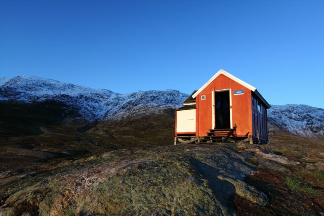
As you arrive in Kangerlussuaq, it’s time to make any final preparations and review your plan. The area that lies ahead is barren, desolate, and remote; your encounters with others from this point until Sisimiut will be few and far between. The trail does offer some respite, however, as there are many shelters constructed along the route. For the sake of the Multi-Cache, it’s important to take note of these shelters as each stage is represented by one. Inside six shelters, there are metal washers with clues to help you decipher the cryptic coordinate puzzle in the cache description.

With the sixth washer and the solution in hand, you can now head to the final coordinates. The journey to the cache is still a long one, but turning around at this point is not an option. After 100 miles (160km) and countless hours, the cache awaits you in a small tundra shrub under a rock. Now the only real question is, do you have enough energy to write in the log book?
All that’s left is to ink your username, seal the cache back up, and replace it. By doing so, you accomplished a feat deemed impossible by some—finding a 100-mile long D5/T5 Multi-Cache. Congratulations, cacher, this has certainly been an adventure for the records! It looks like we’re just in time for our flight out of Sisimiut Airport, too. Unless… no, don’t tell me… you’re ready for the other D5/T5?

Continue to explore some of the most amazing geocaches around the world. Check out all of the Geocaches of the Week on the Geocaching blog. If you would like to nominate a Geocache of the Week, fill out this form.
Source: Geocaching